Plex.Earth Tools for AutoCAD 2010-2015 3.3

Plex.Earth gives you all the tools needed to utilize aerial/satellite imagery
4.6 
Rating
Your vote:
Latest version:
3.3.5296 See all
Developer:
Screenshots
1 / 1
Shareware
Used by 6 people
Download
11.5 MB

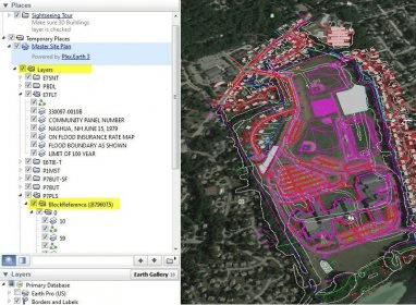
Plex.Earth is an AutoCAD plugin that allows you to use satellite imagery and terrain information from online services such as Google Maps. You can create elevation contours, automatically zoom Map Explorer or Google Earth to your area of interest, or publish your drawing to Google Earth.

Comments (1)

4.6
Rating
7 votes
5 stars
5
4 stars
1
3 stars
1
2 stars
0
1 stars
0
User

Your vote:

D
Powerful tool.

Was it helpful?  yes(0) no(0) | Reply

Related software

AutoCAD Electrical
AutoCAD Electrical
rating

It is a CAD program designed for electrical controls designers.

AutoCAD 2015 Service Pack 1
rating

Update to AutoCAD 2015.

PointCloud CAD 2010
PointCloud CAD 2010
rating

High performance CAD, Surveying and Point Cloud system.

UNBRAKO AutoCAD Product Library
Free
rating

UNBRAKO AutoCAD reduces the design revision time considerably.

ArcGIS for AutoCAD 300
Free
rating

It is a plug-in that provides interoperability between AutoCAD and ArcGIS.

Related suggestions

Tags

Aerial data Aerial image Image data Terrain data Satellite image